Here’s the latest advisory on Super Typhoon Egay according to PAGASA
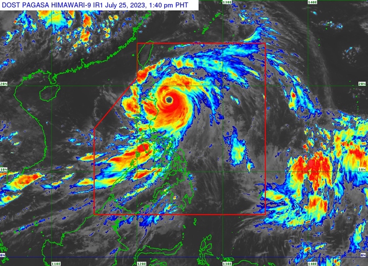
SUPER TYPHOON EGAY – PAGASA announced via its latest bulletin issued at 2 PM today, July 25, 2023, that #EgayPH continues to maintain its strength while moving northwestward.
It is traversing Northwestward at 20 km/h and has maximum sustained winds of 185 km/h near the center and gustiness of up to 230 km/h. The center of the eye of Super Typhoon Egay was located 230 km East Northeast of Tuguegarao City, Cagayan or 240 km East of Aparri, Cagayan (18.1 °N, 123.9 °E ).
Tropical Cyclone Wind Signal no. 5 has been raised in the eastern portion of Babuyan Islands (Camiguin Island) while Tropical Cyclone Wind Signal no. 4 has been raised in the northeastern portion of mainland Cagayan (Santa Ana and Gonzaga) and the rest of Babuyan Islands.
On the other hand, Tropical Cyclone Wind Signal no. 3 has been raised in the northeastern portion of Isabela (Divilacan, Maconacon, Palanan, Santa Maria, San Pablo, Santo Tomas, Cabagan, Tumauini), the rest of Cagayan, Apayao, eastern portion of Ilocos Norte (Vintar, Adams, Pagudpud, Dumalneg, Nueva Era, Carasi, Bangui, Piddig, Solsona), northeastern portion of Kalinga (Rizal, Pinukpuk) and Batanes.
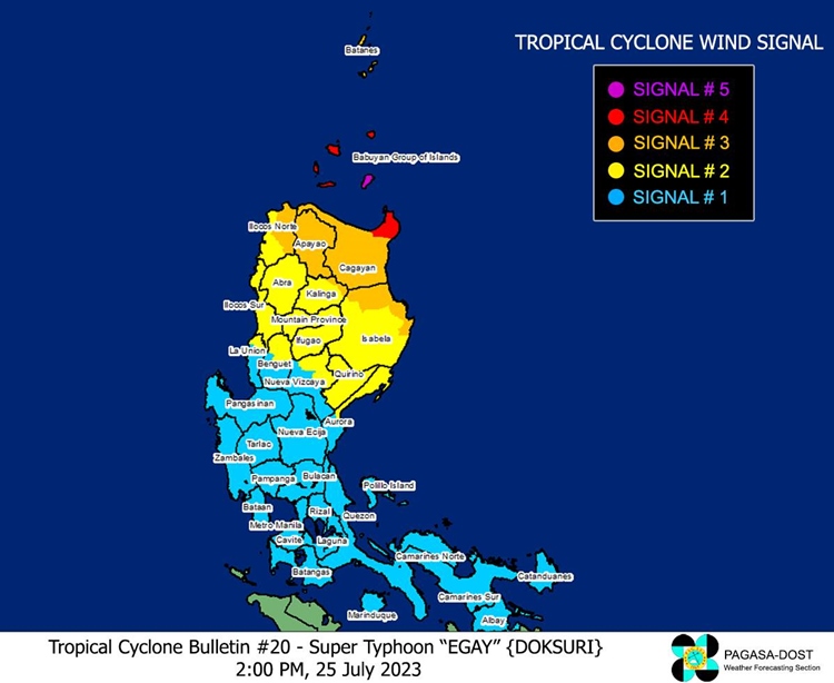
Tropical Cyclone Wind Signal no. 2 has been raised in the rest of Isabela, northern and central portions of Aurora (Dilasag, Casiguran, Dinalungan, Dipaculao), Quirino, the rest of Kalinga, northeastern portion of Nueva Vizcaya (Kasibu, Quezon, Diadi, Bagabag, Ambaguio, Villaverde, Solano, Bayombong), the rest of Ilocos Norte, Ilocos Sur, Abra, Mountain Province, Ifugao, northern portion of Benguet (Bakun, Mankayan, Buguias, Kabayan, Kibungan, Atok) and northern portion of La Union (Bangar, Sudipen, Luna, Balaoan, Santol) while Tropical Cyclone Wind Signal no. 1 has been raised in Quezon including Pollilo Islands, the rest of Aurora, the rest of Nueva Vizcaya, the rest of Benguet, the rest of La Union, Nueva Ecija, Pangasinan, Tarlac, Zambales, Bulacan, Pampanga, Bataan, Marinduque, Cavite, Metro Manila, Rizal, Laguna, Batangas, Camarines Norte, Camarines Sur, Albay, and Catanduanes.
The forecast indicates that areas in the northern portions of mainland Cagayan, Babuyan Islands, Batanes, Ilocos Norte, and Ilocos Sur will experience heavy rainfall. The Southwest Monsoon, enhanced by #EgayPH, will bring monsoon rains to western parts of Central Luzon, Southern Luzon, and Visayas in the next three days. Wind signals have been issued, warning of significant to severe impacts from typhoon-force winds and storm-force winds in different areas.
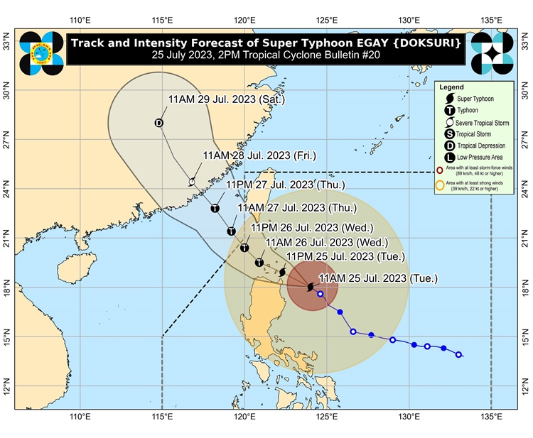
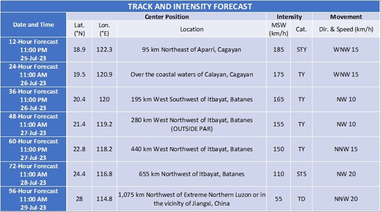
Coastal areas in Batanes, Cagayan including Babuyan Islands, Isabela, and Ilocos Norte are at high risk of storm surge, with maximum surge heights exceeding 3.0 meters in some areas. Gale warnings are also in effect for several coastal waters. #EgayPH is expected to make landfall or pass near Babuyan Islands and northeastern mainland Cagayan before heading towards Taiwan and eventually China. The typhoon is nearing its peak intensity and may slightly intensify in the next 12 hours before weakening due to interaction with Northern Luzon and Taiwan’s terrain.
Meanwhile, according to PAGASA, the next update about Super Typhoon Egay will be issued at 5 PM today. For more news and the latest updates, feel free to visit Newspapers.ph more often as well as our Facebook page and YouTube channel.