Here’s the latest update on Tropical Storm Queenie as of 11 AM today
#QUEENIEPH – The weather disturbance has intensified to Tropical Storm based on the latest update issued by the state weather bureau, PAGASA.
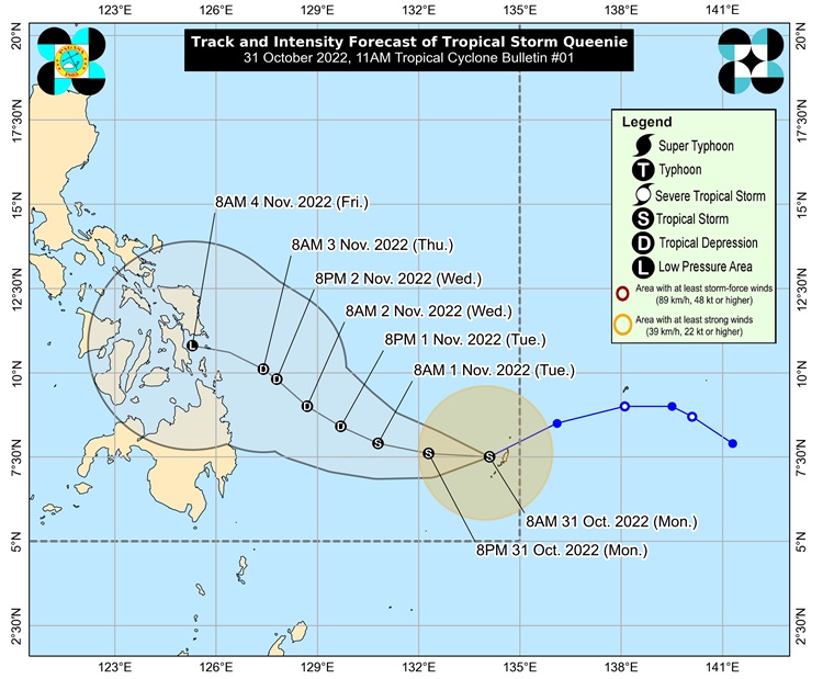
Queenie entered the Philippine Area of Responsibility (PAR) at 5:00 AM today.
It is expected to track westward for the next 12 hours before turning northwesterly tomorrow through Wednesday morning.
The storm will begin to move northwestward toward Caraga-Eastern Visayas by Wednesday afternoon.
Queenie is unlikely to have a significant impact on the country until Tuesday. Light to moderate rains, with isolated heavy rains, are expected to fall over Caraga, Eastern Visayas, and Bicol Region beginning Wednesday.
According to the most recent forecast scenario, a Tropical Cyclone Wind Signal could be issued over the eastern portion of Caraga and in some areas of Eastern Visayas as early as tomorrow evening.
Wind Signal No. 1 is the most likely highest wind signal to be hoisted, based on the most recent track and intensity forecast.
Queenie is less likely to bring rough seas over the country’s coastal waters in the next 24 hours, which could result in hazardous conditions for mariners.
The center of the tropical Storm was estimated based on all available data at 815 km East of Northeastern Mindanao (07.5 °N, 133.7 °E ).
It is moving West Southwestward at 10 km/h with a maximum sustained winds of 65 km/h near the center and gustiness of up to 80 km/h.
Meanwhile, the next advisory about Tropical Storm Queenie will be issued at 5:00 PM today.
Note: This is a developing report. Please refresh this page from time to time for updates.
For more news and the latest updates, feel free to visit Newspapers.ph more often as well as our Facebook page and YouTube channel.