As of 8:00 a.m. of January 17, 2020, the Philippine Institute of Volcanology and Seismology (PHIVOLCS) posted a Taal Volcano Bulletin.
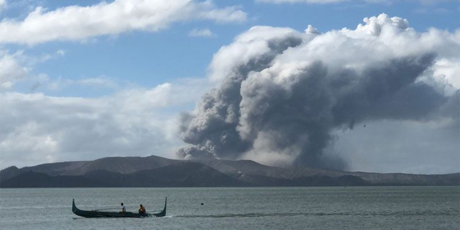
According to DOST-PHIVOLCS, the activity in the Taal Volcano’s main crater in the past 24 hours has been characterized by “steady steam emission and infrequent weak explosions” that generated dark gray ash plumes 100 – 800 meters tall and distributed ash southwest to west of its main crater.
DOST-PHIVOLCS stated that the existing fissures have been observed to widen by a few centimeters in the identified barangays in Batangas Province: Lemery, Agoncillo, Talisay, and San Nicolas. DOST-PHIVOLCS added that a steaming fissure has been observed on the northern slopes of Taal Volcano Island, while the receding of the shoreline has been observed around the whole of Taal Lake.
Based on the reports from the Philippine Seismic Network, they have recorded a total of 634 volcanic earthquakes in Taal region since 1:00 p.m. of January 12. One hundred seventy-four (174) of these volcanic earthquakes were registered at magnitudes M1.2 to M4.1 and were felt at Intensity I to Intensity V.
Since 5:00 a.m. on January 16, 2020 until 5:00 a.m. on January 17, 2020, the Philippine Seismic Network recorded 65 volcanic earthquakes and two (2) of these volcanic earthquakes were registered at magnitudes M1.3 -M3.1 and were felt at Intensity I. The intense seismic activity may signify continuous magmatic intrusion beneath the Taal edifice, in which this may lead to further eruptive activity.
Furthermore, the Taal Volcano Network recorded 944 volcanic earthquakes including 29 low-frequency earthquakes
The alert Level 4 still continued in effect over Taal Volcano, which means, according to DOST-PHIVOLCS, the hazardous explosive eruption will happen within hours to days. The Philippine Institute of Volcanology and Seismology strongly restated the total evacuation of Taal volcano island as well as high-risk areas as identified in the hazard maps within a 14-km radius from its main crater and along the Pansipit River Valley where fissuring has been observed.
The DOST-PHIVOLCS will continually monitor the eruption.
READ ALSO | Netizens Think That This Volcano Is The ‘Real’ Taal Volcano
We must always to pray God that Taal Volcano ‘s victims are safe.