PAGASA Issues Update on Typhoon Uwan amid Storm Raging Areas in PH
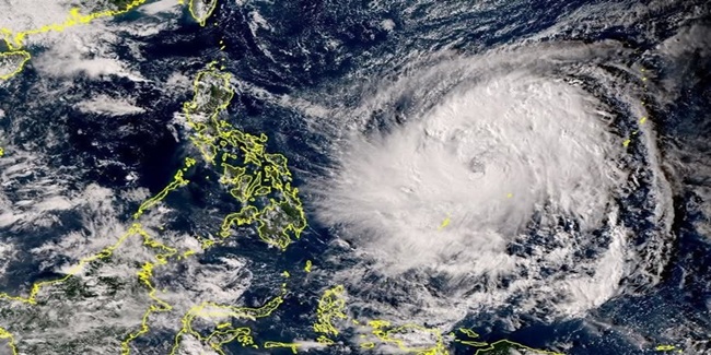
UWAN – The Philippine Atmospheric, Geophysical and Astronomical Services Administration (PAGASA) reported that it has downgraded from “super typhoon” to “typhoon” but 30 areas in Luzon and Visayas still have storm surge threat.
Following the wrath of Typhoon Tino that left the provinces of Cebu and Negros devastated, “Uwan” entered the Philippine Area of Responsibility (PAR) where it intensified into a “super typhoon” and signal no. 5 was previously raised in several areas. PAGASA already warned prior to its entry that it has the possibility of becoming a super typhoon, thus, preparations were urged.
President Ferdinand Marcos Jr. previously assured that all government agencies are under “full alert” for Typhoon Uwan. He stressed that the Department of Social Welfare and Development (DSWD), Department of Public Works and Highways (DPWH), Armed Forces of the Philippines (AFP), and the Philippine Coast Guard (PCG) have prepared lifeboats, rescue vehicles, and relief goods.

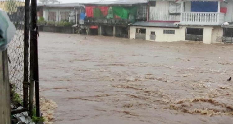
Furthermore, the President also expressed that the Department of Transportation (DOTr) and the Land Transportation Franchising and Regulatory Board (LTFRB) deployed buses and trucks early for the evacuation efforts. Uwan has intensified and become a super typhoon that brought heavy rains that caused flooding in Catanduanes.
Based on the latest update from PAGASA, Uwan has downgraded from the super typhoon into a typhoon after it weakened following its landfall over Dinalungan, Aurora. However, signal no. 4 is still up in the following areas:
- the southwestern portion of Isabela (Cordon, City of Santiago, Echague, Jones, San Agustin, San Guillermo, San Isidro, Alicia, Angadanan, Ramon, San Mateo, City of Cauayan, Benito Soliven, Naguilian, Reina Mercedes, Luna, Cabatuan, Aurora, San Manuel, Roxas, Mallig, Quirino, Burgos, Gamu, Quezon)
- Quirino
- Nueva Vizcaya
- the southern portion of Kalinga (City of Tabuk, Tanudan, Tinglayan, Pasil, Lubuagan)
- Mountain Province
- the southern portion of Abra (Tubo, Luba, Boliney, Villaviciosa, Pilar, Daguioman, Bucloc, Manabo, San Isidro, San Quintin, Pidigan)
- Ifugao
- Benguet
- the central and southern portions of Ilocos Sur (Narvacan, Nagbukel, Santa Maria, Burgos, San Esteban, Santiago, Banayoyo, Lidlidda, San Emilio, Quirino, Cervantes, Gregorio del Pilar, Sigay, Suyo, Alilem, Salcedo, Galimuyod, City of Candon, Santa Lucia, Santa Cruz, Tagudin, Sugpon)
- La Union
- Pangasinan
- Aurora
- Nueva Ecija
- the northern and eastern portions of Tarlac (Concepcion, La Paz, Victoria, City of Tarlac, Gerona, Pura, Ramos, Paniqui, Anao, San Manuel, Moncada, Camiling, San Clemente, Santa Ignacia, Mayantoc)
- The northern portion of Zambales (Santa Cruz, Candelaria)
Despite the downgrade of Uwan into a typhoon from being a super typhoon, based on a report of GMA News, 30 areas in Luzon and Visayas remain at risk of life-threatening storm surge. A storm surge with heights of over 3 meters is expected in the following areas:
- Aurora
- Bataan
- Batanes
- Cagayan
- Ilocos Norte
- Ilocos Sur
- Isabela
- La Union
- Pangasinan
- Quezon
- Zambales
According to PAGASA, storm surge with heights of 2.1 to 3 meters are expected in the coastal areas of the following:
- Aklan
- Antique
- Batangas
- Bulacan
- Cavite
- Guimaras
- Marinduque
- Masbate
- Metro Manila
- Negros Occidental
- Negros Oriental
- Occidental Mindoro
- Oriental Mindoro
- Palawan
- Pampanga
- Romblon
Based on the report, coastal areas in Catanduanes, Camarines Norte, and Camarines Sur remain at risk for storm surge with heights of 1 to 2 meters. PAGASA advised the residents of the above-mentioned areas to stay away from the beach and cancel all marine activities.
Typhoon Uwan came after Typhoon Tino devastated Cebu and Negros provinces and the Philippines is currently under a national state of calamity as declared by Marcos Jr. prior to the entry of “Uwan” to PAR.