Latest Update on Bagyong Tino
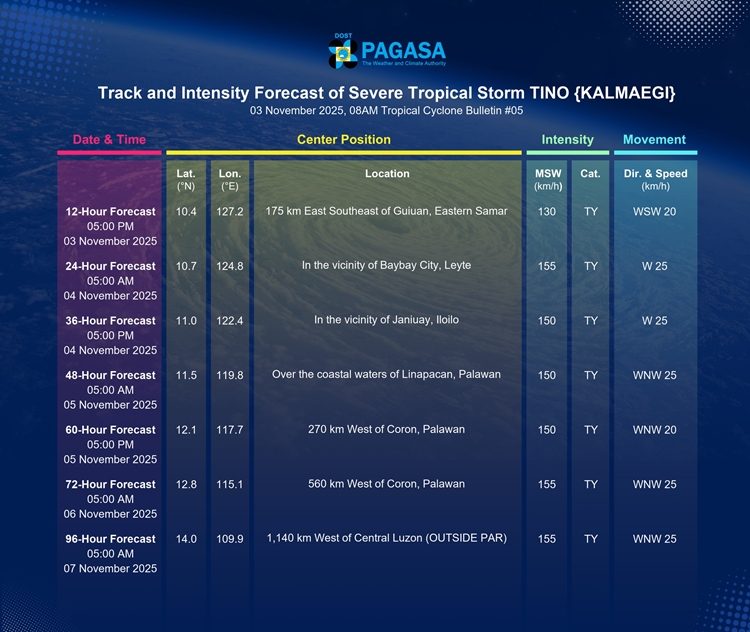
BAGYONG TINO – Severe Tropical Storm “Tino” (international name: Kalmaegi) continues to move west-southwestward and is now close to reaching typhoon strength, according to PAGASA as of 8:00 AM on November 3, 2025.
The center of “Tino” was last located 360 km east of Guiuan, Eastern Samar. It currently carries maximum sustained winds of 110 km/h and gusts of up to 135 km/h, moving at a speed of 25 km/h. The storm’s strong winds extend outward up to 300 km from its center.
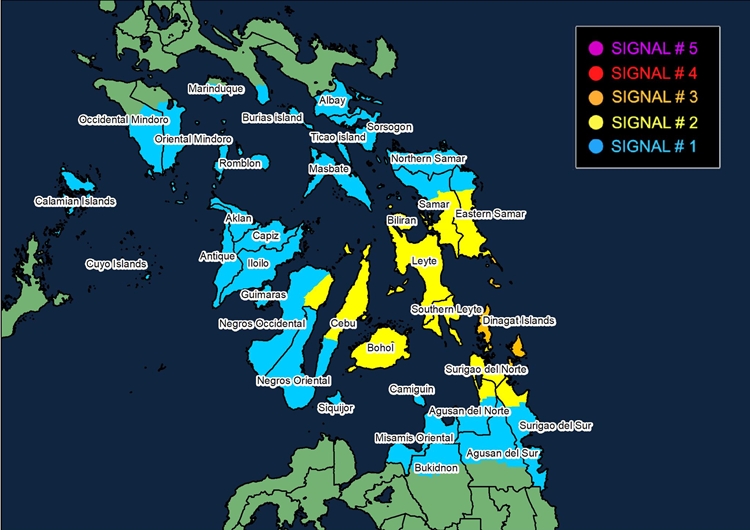
Tropical Cyclone Wind Signals (TCWS) are currently raised over several parts of Visayas and Mindanao. Areas under Signal No. 3, including southeastern Eastern Samar, Dinagat Islands, and Siargao-Bucas Grande Islands, should prepare for storm-force winds that pose moderate to significant threats to life and property.

Signal No. 2 covers much of Eastern Samar, Samar, Leyte, Biliran, Southern Leyte, Bohol, parts of Cebu, Negros Occidental, and portions of Agusan del Norte and Surigao provinces, where gale-force winds may cause minor to moderate damage. Signal No. 1 is in effect over parts of Luzon, Visayas, and Mindanao, including Sorsogon, Masbate, Mindoro, Palawan, and Northern Mindanao, which may experience strong but less damaging winds.
Aside from strong winds, heavy rainfall, flooding, and landslides are expected, especially in areas affected by the shear line and Bagyong Tino. The storm may also bring dangerous storm surges exceeding three meters in low-lying coastal areas of Southern Luzon, Visayas, and parts of Mindanao. Residents in coastal areas are advised to remain alert and evacuate if necessary. A Gale Warning is also in effect, as sea conditions remain very rough to high, with waves reaching up to nine meters in some eastern seaboards, making sea travel extremely risky.
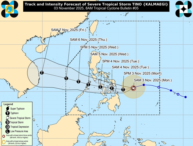
According to PAGASA’s forecast, Bagyong Tino is expected to continue moving westward and may make its first landfall over Eastern Samar, Leyte, Southern Leyte, or Dinagat Islands by late tonight or early tomorrow. It will likely cross the Visayas region and northern Palawan before exiting into the West Philippine Sea by Wednesday, November 5. The storm is expected to reach typhoon status within the next 12 hours and could intensify further, possibly nearing super typhoon strength.