Bagyong Pepito is Still Outside PAR
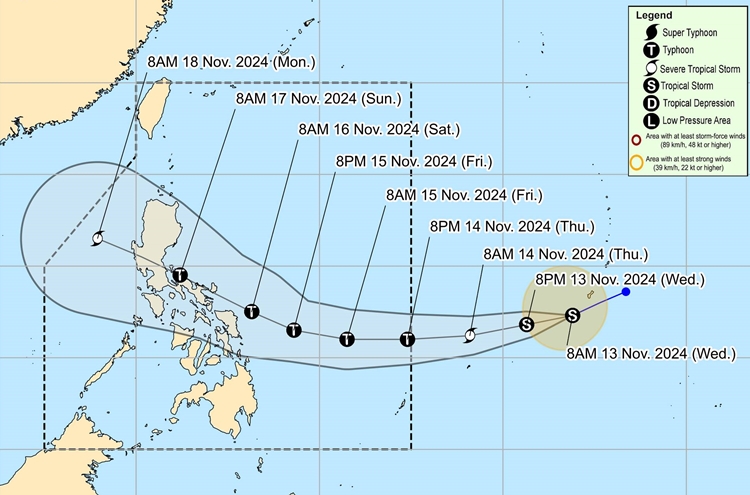
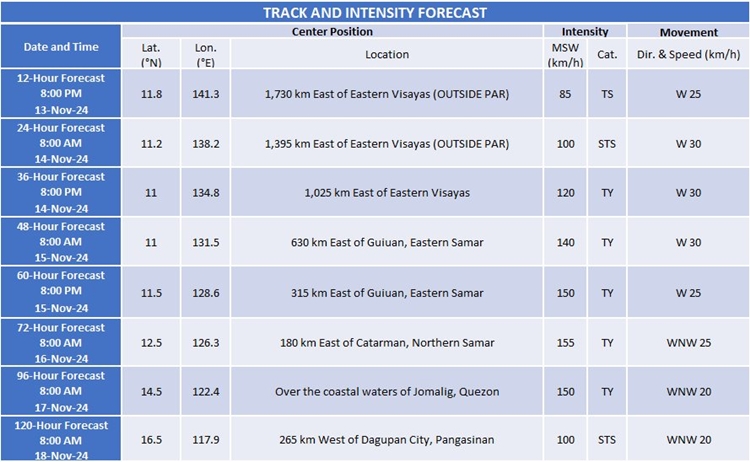
BAGYONG PEPITO – Tropical Storm Man-Yi is expected to enter the Philippine Area of Responsibility (PAR) on Thursday evening, where it will be named “Pepito,” according to PAGASA.
The storm, currently located 1,965 kilometers east of Eastern Visayas and moving west-southwest at 30 kilometers per hour, could intensify into a severe tropical storm by Wednesday and reach typhoon status by Thursday evening.
PAGASA’s forecast indicates that “Pepito” may make landfall on the eastern coast of Luzon over the weekend, specifically on November 16 or 17. The weather bureau has also highlighted the possibility of the storm rapidly intensifying, potentially reaching super typhoon status before landfall.

Currently, Bagyong Pepito has maximum sustained winds of 65 kilometers per hour near its center, with gusts up to 80 kilometers per hour. As the tropical cyclone approaches, PAGASA urges caution, as its intensity may increase, potentially impacting eastern and central Luzon with strong winds and heavy rainfall. The agency has advised residents in these regions to stay informed and be prepared for any adverse weather conditions brought by the storm.

Meanwhile, Typhoon Ofel (international name Usagi) continues to maintain its strength as it moves west-northwestward over the Philippine Sea. As of 10:00 AM on November 13, 2024, the typhoon was located 485 km east-northeast of Daet, Camarines Norte. Ofel has maximum sustained winds of 120 km/h, gusts up to 150 km/h, and a central pressure of 975 hPa. It is moving west-northwestward at 20 km/h.
Currently, Tropical Cyclone Wind Signal (TCWS) No. 2 is in effect over several areas in Luzon, including the eastern portions of Cagayan and Isabela, which may experience gale-force winds within the next 24 hours. TCWS No. 1 is also in effect in other parts of Luzon, where strong winds may occur within the next 36 hours.
Ofel is expected to make landfall along the eastern coast of Cagayan or Isabela on the afternoon of November 14. It will then continue its northwestward movement and slow down before changing direction during the weekend. The typhoon could intensify further, with the potential for rapid strengthening, possibly reaching its peak intensity at landfall.
