Aftermath of Typhoon Carina
TYPHOON CARINA X HABAGAT – The extreme weather disturbance left most parts of Luzon, particularly the National Capital Region (Metro Manila), flooded.
Typhoon Carina is expected to have a reduced impact on heavy rainfall as it exited the Philippine Area of Responsibility (PAR) early Thursday. However, the southwest monsoon, which Carina has intensified, is still forecast to bring moderate to intense rainfall to parts of Luzon until Saturday, according to PAGASA.
As of 6:20 a.m. Thursday, Carina has left PAR. PAGASA’s 5 a.m. advisory indicated that the enhanced southwest monsoon will continue affecting western Luzon with moderate to heavy rainfall through the weekend. An orange warning level remains in effect over Zambales and Bataan due to ongoing flooding risks, while a yellow warning level is in place for Tarlac and Pampanga, signaling potential flooding in susceptible areas.

Metro Manila, Nueva Ecija, Cavite, Batangas, Rizal, Quezon, and Laguna are expected to experience light to moderate rains, with occasional heavy downpours, within the next three hours or before noon, potentially impacting nearby areas as well.

By early Thursday morning, Carina was crossing Taiwan, with maximum sustained winds of 150 kilometers per hour (kph) and gusts up to 250 kph. The typhoon is forecast to exit the northern edge of the Philippine area of responsibility, move over the Taiwan Strait later today, and make its final landfall in China’s Fujian province by evening.

Batanes is now under Signal No. 1, with winds expected to range from 39 to 61 kph in the next 36 hours. PAGASA has lifted tropical cyclone warning signals from other areas.

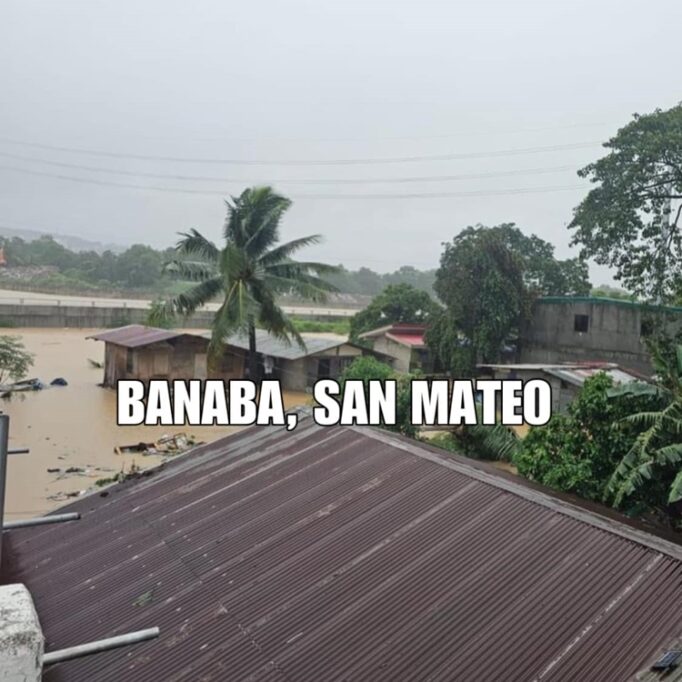
Earlier, the Facebook page Ang Pamilyang Pilipino shared some images of the typhoon’s aftermath and its impact on many cities in Metro Manila. The photos revealed floodwaters nearly reaching the rooftops of neighborhoods, with severe flooding due to the overflow of dams and riverbanks.