Tropical Storm ‘Tino’ May Strengthen into a Typhoon Before Landfall
TINO – The Philippine Atmospheric, Geophysical and Astronomical Services Administration (PAGASA) has sounded the alarm as Tropical Storm ‘Tino’ shows signs of rapid intensification, potentially hitting Eastern Samar or Dinagat Islands as a typhoon within the next 48 hours.
PAGASA warned on Sunday, November 2, that Tropical Storm Tino (international name: Kalmaegi) could rapidly intensify within 48 hours and make landfall as a typhoon over Eastern Samar or Dinagat Islands late Monday, November 3, or early Tuesday, November 4.
In its first tropical cyclone bulletin issued at 11 a.m., PAGASA reported that Tino had maximum sustained winds of 85 kilometers per hour (kph) near the center and gustiness reaching up to 105 kph. The agency noted that “rapid intensification within the next 48 hours is likely” and that Tino could reach typhoon strength within 24 hours. It also mentioned that the possibility of Tino escalating to a super typhoon “is not ruled out based on alternate scenarios and climatological data.”
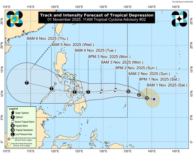
As of 10 a.m., the storm’s center was located 955 kilometers east of Eastern Visayas, moving westward at 30 kph. PAGASA forecasts Tino to continue its westward trajectory over the next three days, making its initial landfall at or near peak intensity—possibly with maximum sustained winds of 150 to 155 kph. After crossing parts of the Visayas and northern Palawan, the storm is expected to emerge over the West Philippine Sea by Wednesday, November 5.
Tropical Cyclone Wind Signal No. 1 was raised over Eastern Samar, Dinagat Islands, Siargao, and Bucas Grande Islands due to the expected strong winds. PAGASA said minimal to minor wind impacts are possible in these areas, while higher wind signals—potentially up to Signal No. 4—may be hoisted if Tino continues to strengthen.
The weather bureau also warned of potential coastal flooding from storm surges in low-lying and coastal areas across the Visayas and parts of Southern Luzon and Mindanao, particularly those near or north of the storm’s projected path. Seas in affected areas are expected to become rough to very rough, with wave heights reaching up to 4.0 meters in some regions. PAGASA strongly advised small boats and inexperienced mariners to avoid sailing under these conditions.

Heavy rainfall is anticipated starting Monday, with 100 to 200 millimeters expected over Eastern Samar, Southern Leyte, Leyte, Cebu, Bohol, Dinagat Islands, and nearby provinces. Additional areas in Luzon and Mindanao may also experience moderate to intense rainfall due to the storm and the prevailing shear line.
PAGASA urged residents in flood-prone and mountainous areas to remain alert for possible flooding and landslides as Tino continues its approach.
READ ALSO: Young Student Among Victims of Typhoon Opong in Masbate