Update on Typhoon Tino amid Heavy Rains in Palawan
TYPHOON TINO – PAGASA raised signal number 4 in some areas in Palawan as the severe tropical storm makes its landfall in Batas Island.
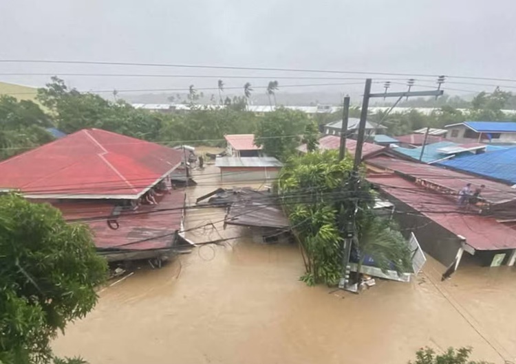
Currently, several areas in the Philippines are experiencing heavy rains and strong winds due to severe tropical storm Tino which left Cebu and several areas in the Negros province severely affected. The heavy rainfall in Cebu caused massive flooding that triggered not only evacuation but as well as rescue operations as many residents had no choice but to climb on their rooftops for their safety.

Previously, PAGASA issued a storm surge warning in 30 areas in Visayas and Mindanao due to Typhoon Tino. In the province of Cebu, the water in dams overflowed that triggered massive flooding in different cities. Aside from the ground level of several homes being left submerged in floodwater, several vehicles collided and even piled up due to the typhoon.
Typhoon Tino is expected to cross Palawan before it will make its exit through the West Philippine Sea either on the eve of Wednesday (November 5) or early Thursday (November 6). PAGASA previously confirmed that Tino will remain a typhoon until it exits the PAR.
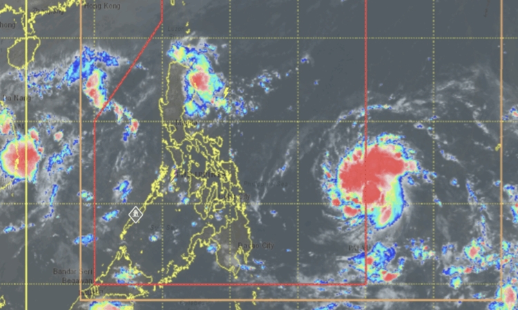
Based on a report on GMA News, Typhoon Tino has made its first landfall in Batas Island, town of Taytay and some areas in Palawan are currently under tropical cyclone wind signal no. 4. PAGASA warned that the severe tropical storm “will affect the locality” with winds moving at no less than 118 kilometers per hour up to 184 kilometers per hour in at least 12 hours.
The following tropical wind cyclone signals are up in these areas:
Signal No. 4
- El Nido, Taytay, Araceli in Palawan
Signal No. 3
- northern portion of Palawan (Dumaran, San Vicente, Roxas)
- Cuyo Islands
Signal No. 2
- southern portion of Occidental Mindoro (Magsaysay, San Jose, Rizal, Calintaan)
- southern portion of Oriental Mindoro (Bulalacao
- central portion of Palawan (Puerto Princesa City) including Cagayancillo Islands
- all in Luzon
- Caluya Islands
Signal No. 1
Luzon
- the rest of Occidental Mindoro including Lubang Islands
- the rest of Oriental Mindoro, the western portion of Romblon (Santa Fe, Santa Maria, Concepcion, Looc, Alcantara, Odiongan, San Jose, Ferrol, San Andres, Calatrava, Corcuera, San Agustin)
- the southern portion of Palawan (Aborlan, Quezon, Narra, Sofronio Española) including Kalayaan Islands
Visayas
- Aklan, the rest of Antique, the central and western portions of Capiz (Sapi-An, Tapaz, Ivisan, Cuartero, Dumalag, Sigma, Dao, Mambusao, Jamindan, Dumarao)
- the central and southern portions of Iloilo (Calinog, New Lucena, Maasin, Oton, Pavia, Dueñas, Barotac Nuevo, Guimbal, Iloilo City, Tigbauan, Anilao, San Miguel, Leon, Mina, Santa Barbara, Leganes, Dingle, Zarraga, Bingawan, Cabatuan, Alimodian, Dumangas, San Joaquin, San Enrique, Badiangan, City of Passi, Pototan, Lambunao, Tubungan, Igbaras, Janiuay, Miagao)
- Guimaras
The center of Typhoon Tino was estimated over the coastal waters of Linapacan, Palawan moving in a west northwestward direction at a speed of 15 kilometers per hour up to 120 km/h sustained winds. Based on the report, the gustiness of the typhoon was recorded of up to 150 km/h.
According to PAGASA, even in localities outside the eye of the severe tropical storm, heavy rainfall, storm surge, and severe winds may still be experienced. Typhoon Tino is expected to re-intensify in the next 12 hours.
Reportedly, at least 26 people were confirmed dead as Typhoon Tino ravaged central Philippines.